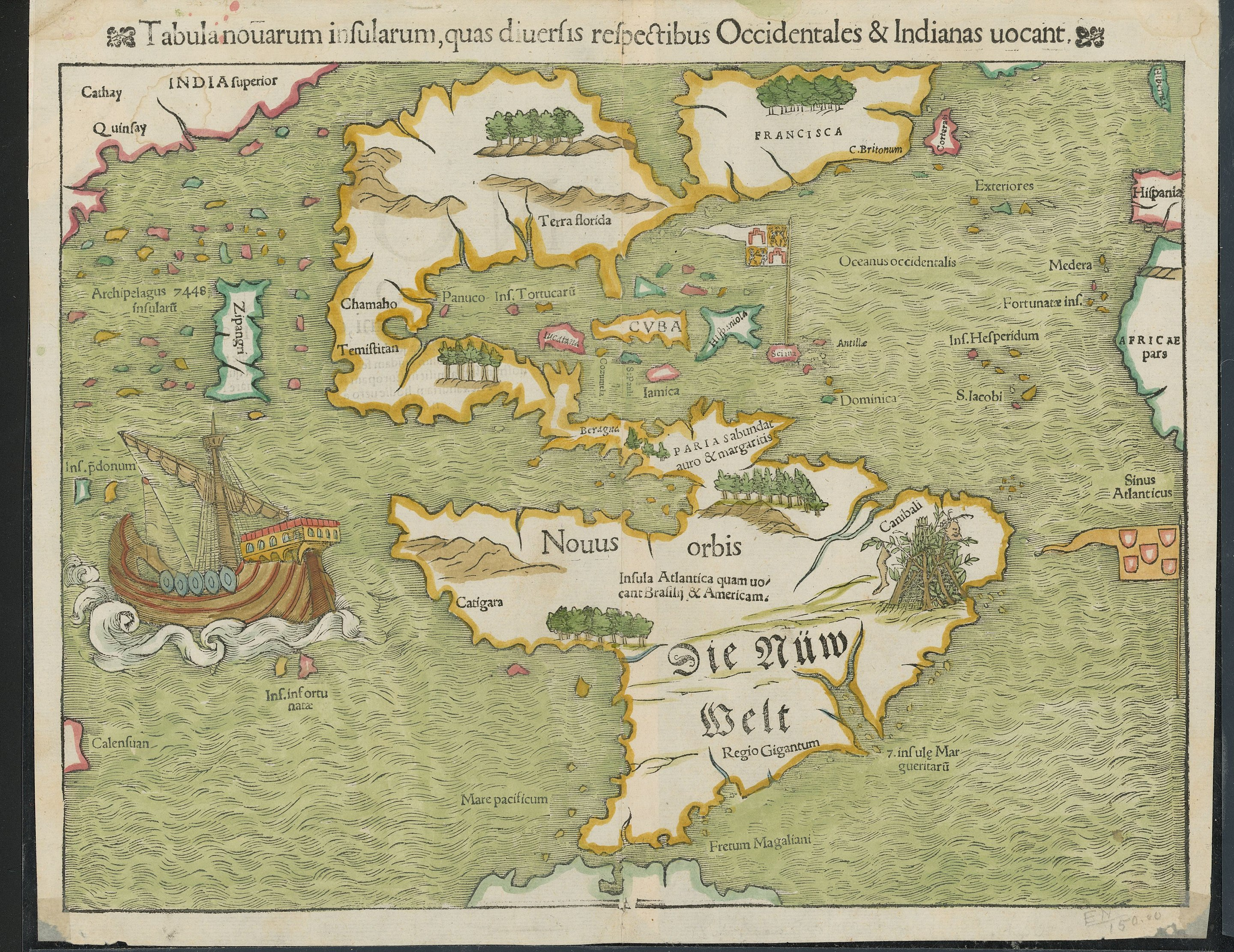
353
More info here: https://exhibits.stanford.edu/ruderman/catalog/mz230kn1495
We learn something new every day. This is a community dedicated to informing each other and helping to spread knowledge.
The rules for posting and commenting, besides the rules defined here for lemmy.world, are as follows:
Rule 1- All posts must begin with TIL. Linking to a source of info is optional, but highly recommended as it helps to spark discussion.
** Posts must be about an actual fact that you have learned, but it doesn't matter if you learned it today. See Rule 6 for all exceptions.**
Rule 2- Your post subject cannot be illegal or NSFW material.
Your post subject cannot be illegal or NSFW material. You will be warned first, banned second.
Rule 3- Do not seek mental, medical and professional help here.
Do not seek mental, medical and professional help here. Breaking this rule will not get you or your post removed, but it will put you at risk, and possibly in danger.
Rule 4- No self promotion or upvote-farming of any kind.
That's it.
Rule 5- No baiting or sealioning or promoting an agenda.
Posts and comments which, instead of being of an innocuous nature, are specifically intended (based on reports and in the opinion of our crack moderation team) to bait users into ideological wars on charged political topics will be removed and the authors warned - or banned - depending on severity.
Rule 6- Regarding non-TIL posts.
Provided it is about the community itself, you may post non-TIL posts using the [META] tag on your post title.
Rule 7- You can't harass or disturb other members.
If you vocally harass or discriminate against any individual member, you will be removed.
Likewise, if you are a member, sympathiser or a resemblant of a movement that is known to largely hate, mock, discriminate against, and/or want to take lives of a group of people, and you were provably vocal about your hate, then you will be banned on sight.
For further explanation, clarification and feedback about this rule, you may follow this link.
Rule 8- All comments should try to stay relevant to their parent content.
Rule 9- Reposts from other platforms are not allowed.
Let everyone have their own content.
Rule 10- Majority of bots aren't allowed to participate here.
Unless included in our Whitelist for Bots, your bot will not be allowed to participate in this community. To have your bot whitelisted, please contact the moderators for a short review.
You can view our partnered communities list by following this link. To partner with our community and be included, you are free to message the moderators or comment on a pinned post.
For inquiry on becoming a moderator of this community, you may comment on the pinned post of the time, or simply shoot a message to the current moderators.
More info here: https://exhibits.stanford.edu/ruderman/catalog/mz230kn1495
Now I really want to see an animation of what the European discovery of the planet looked like. Imagine a time lapse of a Civilization game, as the map is slowly revealed. I want to see that, except actual history.
Also make the map shape and style match that times maps.
Anyone know what Zipangri is? Could that be Baja California, or what?
Edit: Japan. Is apparently just off the coast of Mexico
This makes sense given the popular knowledge at the time. The reason Columbus set sail wasn't because he was a genius that knew the Earth was round when everyone else didn't. We knew the Earth was round since antiquity. I can't remember who^1^, but some ancient Greek had calculated the circumference of the Earth using the angle of a shadow, distance to a ~~equinox~~ solstice, and simple trigonometry. They guy was less than 5% off with his rudimentary calculation, which is impressive considering that he paid some dude to measure the distance between two towns by walking it. Anyways, the Western Europeans thought that Japan was farther east, somewhere around where the words "Terra florida" are on this map if I recall correctly from memory. When the Niña, Pinta, and Santa Marimba (party boat! jk, it was Santa Maria named after the "virgin") landed on the most beautiful land that human eyes had ever seen, they knew they hadn't landed on Zipangri/Cipangu/Japan. Instead, they thought they had landed on some island off of India, which is why they called the locals "Indios" (Indians). Anyways part 2, they thought that Japan was much further east than it was. I imagine that since they hadn't found it for this map yet, they though it must be right out of sight of the western coast of North Vespucci (America).
What I'm curious about is that 7448 inflating archipelago. Anyone have an idea on what that's about?
1: The dude was Eratosthenes. Thanks, @[email protected]!
Santa Marimba
I'm stealing this! 😂
lol, I updated it with a silly link for more even fun 😋
It's not "inflating", it's "insularum" (they also used to use the tilde as a shorthand for m and n), using the old long s
The El Niña weather event, the Piñata and the Santa Claus.
perfect! 😆
Apparently Japan's shape wasn't well known either
I had guessed it was Sri Lanka since it is also shown just off the coast of India. Then I figured it was more likely Indonesia given it's surrounded by so many other islands and not that close to India. But yeah, now that I know that the name meant Japan I'm wondering if it's depiction on the map is a conflagration of accounts of Indonesia and Japan.
Given the lack of shape, it could be just about anything - I wonder if it was one report, or hearsay with no details and they filled in something
They were generally working with very, very rough, incomplete, conflicting, or confusing info, yes.
It's pretty astounding to me that this is even remotely as accurate as it is.
That explains the pearl harbour
Before seeing your comment and searching myself, I wondered if it was California as well, since it was thought that California was an Island for some time.
cuba has always been cuba?!
I'm guessing the Taino called it something else.
Looks like they called it Cuba
either "great place" or "where fertile land is abundant"
So..first impressions pretty positive?
FWIW, this gives a somewhat different origin, although says it is derived from the local name.
ha, good point. i was just kinda shocked to see a legible 'cuba' and 'florida'
Terra florida means something like "land with many flowers" in Spanish.
IIRC their word was something like "Kolba"
I really really want to find a good book or website showing the extended evolution of maps of the world or specific areas. This stuff fascinates me.
I've found a few minor ones over the years, but never a good one.
Sort of map-related, but the Longitude series/book is pretty fascinating. This map was drawn without really being able to calculate longitude except by dead reckoning.
I absolutely love wildly inaccurate old maps. They have so much charm.
So are we not gonna talk about the whole area labels for cannibals?
We are now.
What'd you want to talk about?
Ships were huge in the 1500s!
The water is colored green. Took my mind a bit of time to realize the land is water and the water is land
Probably azurite paint aging. Turns green (Edit: forgot to mention because it turns into malachite) over time and was super common Europe.
It's why a ton of Renaissance art has greens where you'd expect blues
How in sam hill are their vowel Vs and consonant Us in this‽
Musta been a cold day in North America.
Man what a shit map, they are horrible at cartography /s
This dumbass didn’t even know the Maps app is free.
i like how our boi did highlighter colors.
superior india is just right of china. probably quinfay there is "shanghai".
there's also that canibali place with bush tents hung with a leg and a happy face.
Obviously the green part is the ocean.
Pretty good map for the 16th century anyhow, except India being where Russia would be
"India" did not mean then what it does now.
The only label on the map that's both on Latin and in old German.
"Regio Gigantum?" So below the Cannibals and Ze German Belt, lies the land of giants?
Sibera was part of India back then.
wow. spain is north of florida.
As it should be... Navigators could determine latitudes pretty accurately by using astronomy. It was the longitude that was a big problem (maybe that's part of the reason Japan is placed in the middle of the Pacific).
There was a British miniseries about John Harrison, the clockmaker who figured out how to measure longitude, with Jeremy Irons and Michael Gambon. Worth watching if you can find it or want to watch the shitty quality versions on YouTube.