It's a light pollution map!
!nostupidquestions is a community dedicated to being helpful and answering each others' questions on various topics.
The rules for posting and commenting, besides the rules defined here for lemmy.world, are as follows:
Rule 1- All posts must be legitimate questions. All post titles must include a question.
All posts must be legitimate questions, and all post titles must include a question. Questions that are joke or trolling questions, memes, song lyrics as title, etc. are not allowed here. See Rule 6 for all exceptions.
Rule 2- Your question subject cannot be illegal or NSFW material.
Your question subject cannot be illegal or NSFW material. You will be warned first, banned second.
Rule 3- Do not seek mental, medical and professional help here.
Do not seek mental, medical and professional help here. Breaking this rule will not get you or your post removed, but it will put you at risk, and possibly in danger.
Rule 4- No self promotion or upvote-farming of any kind.
That's it.
Rule 5- No baiting or sealioning or promoting an agenda.
Questions which, instead of being of an innocuous nature, are specifically intended (based on reports and in the opinion of our crack moderation team) to bait users into ideological wars on charged political topics will be removed and the authors warned - or banned - depending on severity.
Rule 6- Regarding META posts and joke questions.
Provided it is about the community itself, you may post non-question posts using the [META] tag on your post title.
On fridays, you are allowed to post meme and troll questions, on the condition that it's in text format only, and conforms with our other rules. These posts MUST include the [NSQ Friday] tag in their title.
If you post a serious question on friday and are looking only for legitimate answers, then please include the [Serious] tag on your post. Irrelevant replies will then be removed by moderators.
Rule 7- You can't intentionally annoy, mock, or harass other members.
If you intentionally annoy, mock, harass, or discriminate against any individual member, you will be removed.
Likewise, if you are a member, sympathiser or a resemblant of a movement that is known to largely hate, mock, discriminate against, and/or want to take lives of a group of people, and you were provably vocal about your hate, then you will be banned on sight.
Rule 8- All comments should try to stay relevant to their parent content.
Rule 9- Reposts from other platforms are not allowed.
Let everyone have their own content.
Rule 10- Majority of bots aren't allowed to participate here.
Our breathtaking icon was bestowed upon us by @Cevilia!
The greatest banner of all time: by @TheOneWithTheHair!
It's a light pollution map!
I'm not sure what you're looking for.
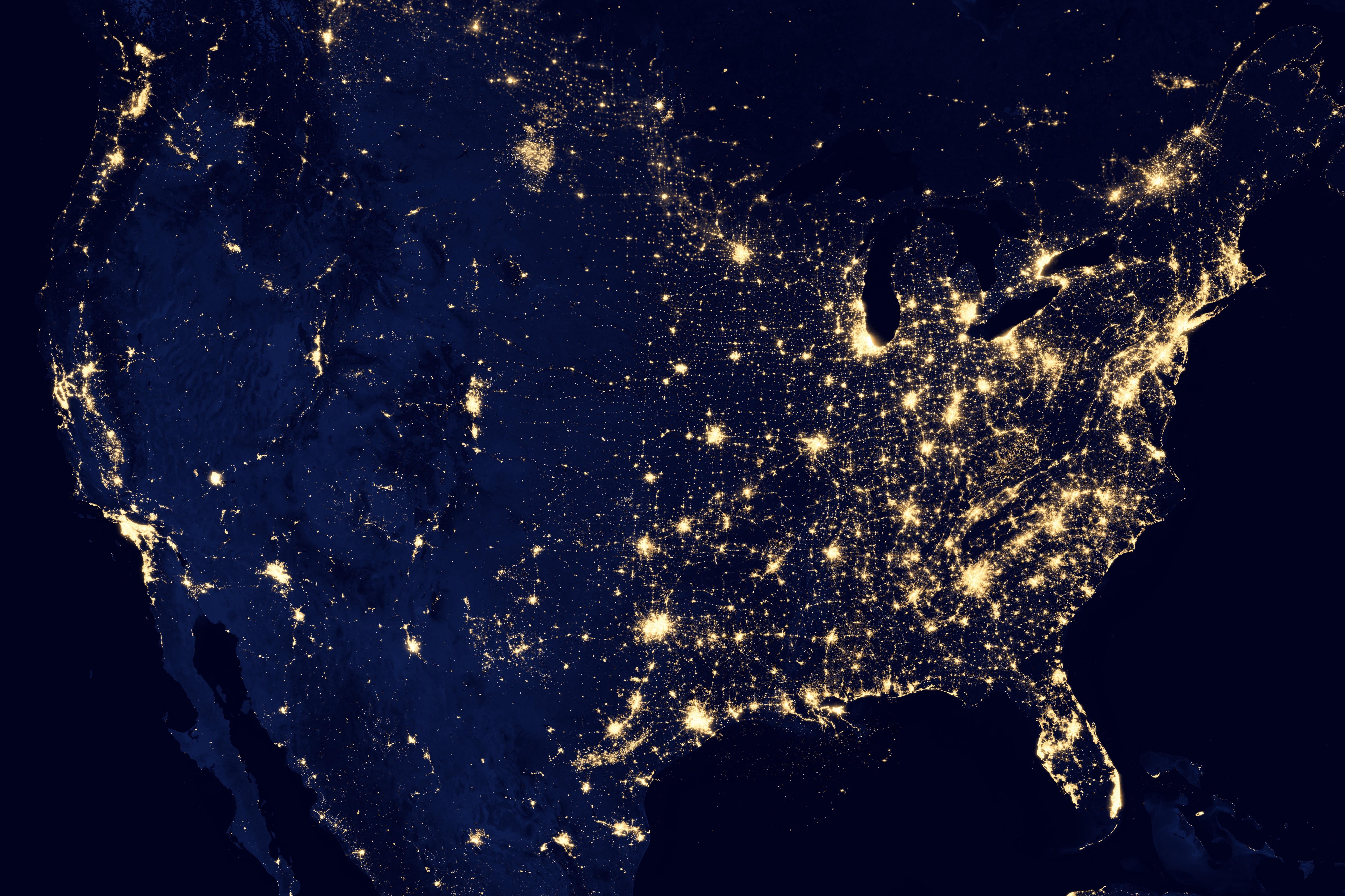
This is a composite satellite image of nighttime light sources.
I can't think of anything unifying other than "satellite image".
Thanks
This looks like a nasa image in their series "earth at night". Looks like they do this every few years; they did one in 2012 and in 2016. Every once in a while I get a hankering to check it out, and for a while I could never remember what they were called.
Here's the USA specific one from 2016: https://www.usgs.gov/media/images/photograph-united-states-night
Here's the global version: https://earthobservatory.nasa.gov/features/NightLights/page3.php
Satellite image at night.
Nighttime satellite light map?
Thanks
I named it Gerald.
The community is called No Stupid Questions but apparently it does have stupid answers.
Okay in all seriousness, this kind of comment is not helping the asker at all.
Maybe not, but it apparently helped mildly amuse significantly more folks than it pissed off so I'm happy with it.
To me it looks more like a Bertha.
My understanding is that's literally what a big chunk of North America looks like at night, when viewed from space with a sufficiently long camera exposure. This specific image may be composed of many exposures, but it's not a cartogram or something; it's a composite photograph.
Mostly you're seeing electric lighting, which is clustered around places where people live and have the resources to light up their buildings and streets -- so that people can see, drive, and be safe at night.
It kinda shows the dominance humans have over the planet. We affect nearly every part of it. Nearly everything is light up by our lights.
To the point where it's visible from space. From space, it's as if we have altered all of the night's topography.
Thanks
The picture is clearly at the very least a composite, because there are zero clouds anywhere. I was skeptical whether it can be called a "photo". Given how clear the unlit terrain is, even in the ocean around the Bahamas for example, I thought it must have been a visualization, or a photo of daytime terrain shaded blue and overlaid with a map of nighttime lights. But I found the actual source:
https://earthobservatory.nasa.gov/images/79765/night-lights-2012-map
https://eoimages.gsfc.nasa.gov/images/imagerecords/79000/79765/dnb_land_ocean_ice.2012.13500x13500.B1.jpg
It really is a (composite) photo taken by the Suomi National Polar-orbiting Partnership satellite, whose cameras are so sensitive they can see reflected moonlight and "the nocturnal glow produced by Earth's atmosphere", albeit partially in the infrared.
This new image of the Earth at night is a composite assembled from data acquired by the Suomi National Polar-orbiting Partnership (Suomi NPP) satellite over nine days in April 2012 and thirteen days in October 2012. It took 312 orbits and 2.5 terabytes of data to get a clear shot of every parcel of Earth’s land surface and islands.
The nighttime view of Earth was made possible by the “day-night band” of the Visible Infrared Imaging Radiometer Suite. VIIRS detects light in a range of wavelengths from green to near-infrared and uses filtering techniques to observe dim signals such as gas flares, auroras, wildfires, city lights, and reflected moonlight.
I'm unsure though what "assembled from data" means exactly. At the very least the colors are artificial, shifted from the infrared-to-green range of the camera into human visual range. This page describes some more how the sensor functions, along with raw photos:
https://earthobservatory.nasa.gov/features/IntotheBlack
Looks like a planning map for high speed rail to me
If you’re talking data viz, maybe a dichromatic chloropleth geo chart or a hot spot/density map?
Yeah heat map seems to be the most generic term for it.
idk, a light map? you trying to Google it? or just for the trivia knowledge?
!solved
Unsolved?
Found the programmer.
What color is this dress?
Black and gold
Don't get me started, it white and...!
Baaabbbaaaa yeettuuuu yeettuuuu leeeyyaaaiiie.... 🎶
satellite map.
Where’s Waldo?
Crazy how sparsely populated the US is west of Dallas, TX.
It's mostly desert and mountains
The east / west division in the cost of light bulbs.
Slightly off-topic but recently I saw a bunch of these under the rayshader tag on mastodon, seems like https://fosstodon.org/@terence posts a lot of them if you want to check some out (edit: I might want to clarify that they are likely generated based on data rather than photos from space, though)
Not gonna lie. These are dope. Should sell high resolution online
JPEG
and i like JPEGS
Uhhh... A picture?
Yes!! finally, thank you
Geoplot?
Color
Picture